язык курса
длительность курса
понадобится для освоения
для зачета в своем вузе
за обучение
Dear learners, please note that only part of the materials is available for free viewing. All course materials will be available after certification payment.
The purpose of the course is to provide students with knowledge about the technology of aerial photography using unmanned aerial vehicles (UAVs).
The course objectives include: knowledge about various aircraft and payloads, the geodetic control creation, flights planning and their implementation, the main stages of data processing and application of the results obtained.
The course developed by SPBU together with Geoscan Group – the leading Russian UAV manufacturer and processing software developer. This allowed us to make the course fulfilled with the practical aspects of aerial photography with UAV.
Distance-learning
No prior experience required.
UNIT 1:
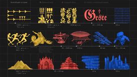
- Aerial Photography. History, Application, Trends
-Unmanned Aerial Vehicle. Сlassification
-Unmanned Aerial Vehicle Construction
-UAV and Aerial Photography Services Market Review
-UAV: Payload Types
UNIT 2:
-Types of Coordinate Systems
-Types of Coordinate Systems and Vertical Datum
-Geodetic Control Network and Coordinate Transformation
-Goals and Objectives Shooting Support GNSS Method
-Introduction to GNSS
-Methods Used in GNSS Measurements
-High Precision Methods
UNIT 3:
-Aerial Photography Requirements, Reconnaissance
-Ground Control Station Introduction
UNIT 4:
-Geoscan 101 Geodesy Package and Assembly
-Parachute Folding
-Battery Operation
-Launcher Package and Assembly
-Application of the Geoscan 101 Geodesy
-Build Flight Mission
-Prelaunch and Flight
-After-Flight Activities
-Group Application of the Complex
UNIT 5:
-Using ITRF Survey Points
-Static GNSS Data Processing
-Kinematic GNSS Data Processing
-Real-time Kinematic
-Using ITRF Survey Points
UNIT 6:
-Introduction to Photogrammetry
-Digital Photogrammetric Processing Basics. SIFT Algorithm
-Photogrammetric Software Overview
-Resulting Materials and Their Application
Upon completion of this course, students will be able to:
- Select the aircraft and payloads depending on the task and terrain conditions;
- Plan flight mission.
Students will know:
- The UAV composition;
- Requirements for geodetic control of flights;
- Data processing;
- Types of the results and their usage.
The discipline is aimed at the formation of universal competencies of students in the educational programs of the bachelor's / specialist's degree, as well as other competencies provided for by the educational program.
ОПК-5. Способен инсталлировать и сопровождать программное обеспечение информационных систем и баз данных, в том числе отечественного происхождения, с учетом информационной безопасности
язык курса
длительность курса
понадобится для освоения
для зачета в своем вузе
за обучение

Должность: ГК "Геоскан", оператор БПЛА

Должность: Руководитель отдела в компания "Джи Динамика"

Должность: Доцент кафедры картографии и геоинформатики

Должность: старший преподаватель кафедры картографии и геоинформатики
По данному курсу возможно получение сертификата.
Стоимость прохождения процедур оценки результатов обучения с идентификацией личности - 3600 Р.

К сожалению, мы не гарантируем корректную работу сайта в вашем браузере. Рекомендуем заменить его на один из предложенных.
Также советуем ознакомиться с полным списком рекомендаций.